Wednesday, August 22, 2018

Etna, CA

The alarm went off early this morning as I wanted to get hiking as soon as it was light enough to see the trail clearly. When I was just about to load up I went to the creek and saw that the cows had completely trashed the water source I had used the night before. Before and after images. 


Plus there were cow “plops” above and right in the pool of water that crossed the trail. Cows are cute and all but they sure tear up water sources. I’m glad I got mine last night and didn’t have to get more this morning. 

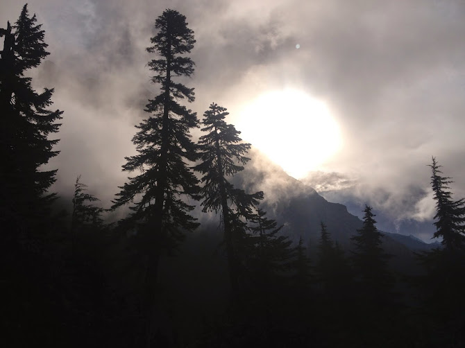
Again, the skies were very smoky this morning. Seemingly thicker than yesterday and it affected my breathing somewhat. Not horribly but it affected my mood. I just wanted to get out and into better air. 

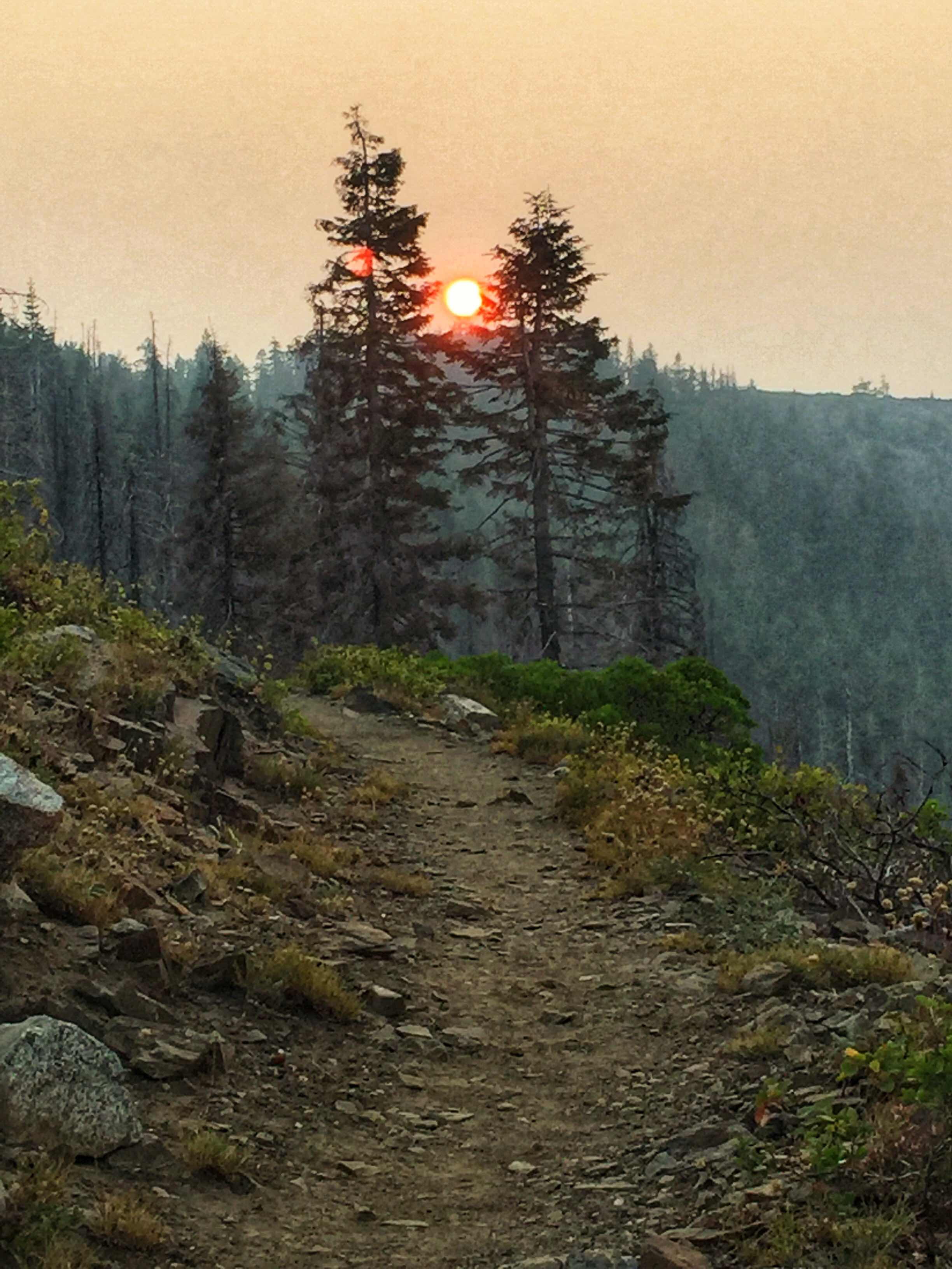
It does make for interesting light though. 

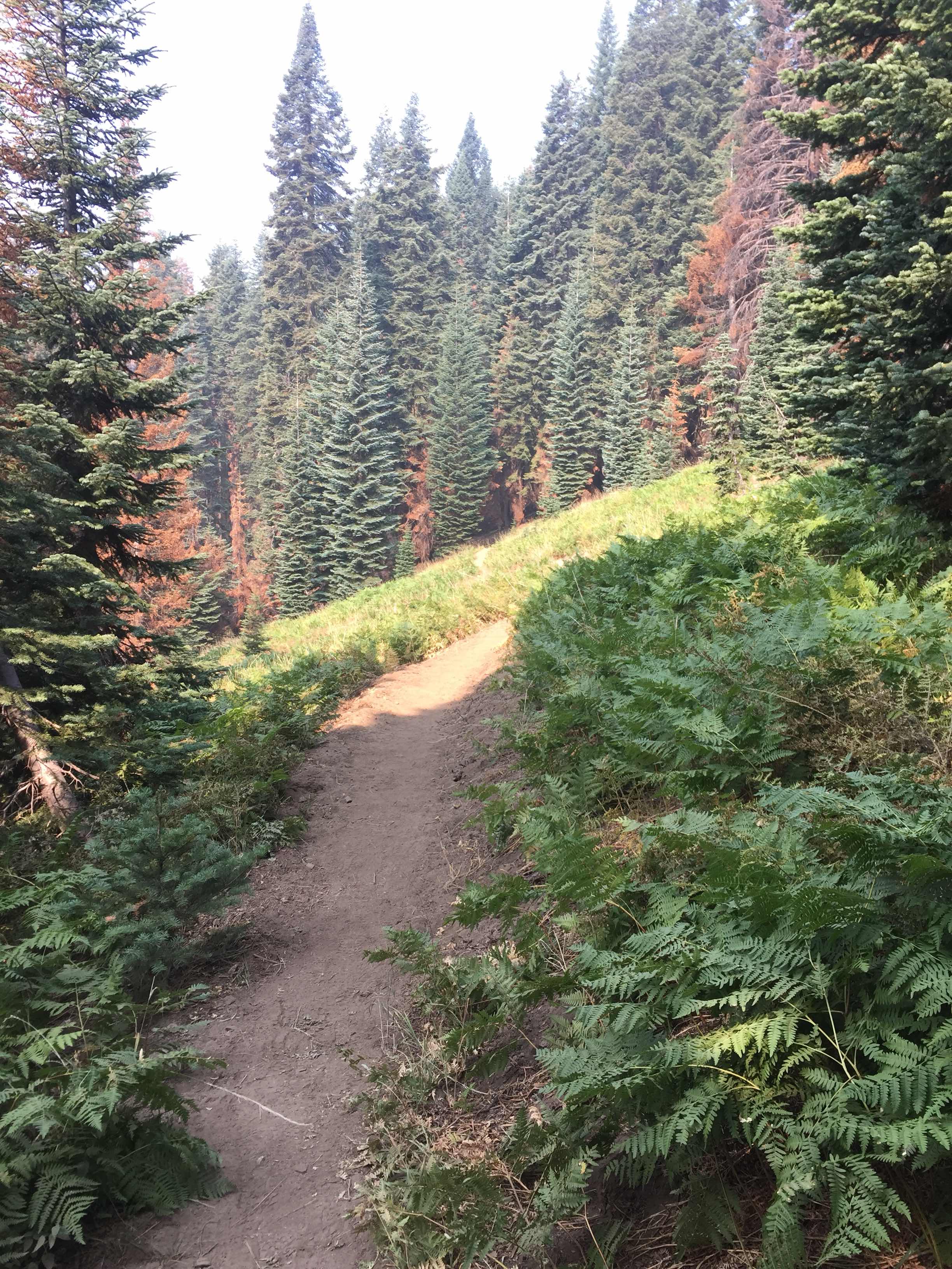
I simply put my head down and walked, reaching the high point about 10:30. Once I started the 3 mile down hill part of the hike to my car I finally arrived back to a no burn area. I hadn’t noticed it on the way in as it was just forest. It was only once I’d been in fire devastated area for so many miles that I recognized the relief of being back under healthy trees. 

And flowers!


48 hours after leaving my vehicle at the trailhead I walked back out to my van. Relieved to have made it out without having to walk in the heat of the day and anxious for a shower. 

It was a successful trip by any account. I’m pleased to have gotten the missing miles done and happy to have made it without injury, other than the oh-so-sore muscles in my legs. Ouch. But they will repair in a couple of days and I’ll be good to go. I’ll decide tomorrow whether or not to continue on to Sierra City to pick up the missing 10 miles in that area. In the meantime, goodbye to the


Shelly Meadow Campsite

I woke up this morning to smokey skies. This is the same view as last night, without the view. What a difference a few hours and some wind make. 
It was very disconcerting since I have no way of knowing if the smoke is from an old fire and being blown this way or is it a new fire and I’d better get the hell out of Dodge. I wavered, then packed up and walked back to the trail. Three nobo’s had camped at the nearby view spot and I asked them what they knew about the smoke. They said they didn’t know of any new fire but it was probably old smoke blowing in. I guess they’ve been walking in this kind of smoke for weeks and they were very matter of fact about it. So I decided to at least walk to the next spot and see from there what to do. 

When I got to Shelly Lake outlet the smoke seemed no worse so after breakfast and gathering water I headed out to hike the three miles to my “lift off” spot. The trail was relatively gentle, some up some down though I had to walk through more burn areas. 

But occasionally there would be an area that wasn’t devastated by fire and I’d get to see what it might have looked like before 2017. Still some burned trees but more of a mosaic of healthy trees along with the burned ones. 
I reached Hemlock Campsite around 11:30, intending to eat lunch and just linger there for a bit. But the area was swarming with yellow jackets and I couldn’t stay beyond eating lunch. It certainly wasn’t restful as I had to move around as I ate. So I packed up and said goodbye to Hemlock camp. This is an image of the nearby hill where the helicopter had dropped the hoist. 
Walking the three miles back to Shelly Meadow I arrived around 1:30. My legs were sore so I just decided to stay here for the rest of the day and night. I hung my hammock and rested, listening to a book on my phone. Some clouds started to float past so I put up my tarp, just in case. 
Cooking dinner hadn’t brought out hordes of yellow jackets, just a couple of persistent buggers. So I got inside my hammock, with bug screen, and ate my turkey stroganoff in peace. 
This whole area is being grazed by cattle, every one of which has a bell around its neck. This means there is a constant clanging sound in the background. Sometimes in the distance and sometimes up close and personal. 


They didn’t much like the fact that I was here and were very skittish. As was the water snake I saw swimming along a small water channel near my spot. 
Hopefully my legs will be up for a 10.5 mile day tomorrow. They weren’t very happy with the 9 miler today, but we will see. There is always vitamin I. 

Tuesday, August 21, 2018

Bear Cub Spring - elevation 6,320’

I spent hours this morning trying to get my Inreach set up. I finally had to delete then reinstall the application again. I do believe it is working though. What this means is that I didn’t leave Ashland till 9:30, guaranteeing I wouldn’t get on the trail till it was in the heat of the day. 

The road to Etna summit is steep and not marked so I had a bit of trouble finding it once I got to Etna. I finally found the Hiker Hut (a kind of hostel) and asked them if the road I was on was the correct one. By luck I had found it so off I went. I arrived around noon and pulled off the road at what I assumed was the trailhead. Again, no signs. But my Halfmile’s Map application located me right at the PCT. Good news all around. 

As I was organizing myself a car pulled up and the driver said “Hey I remember you!” It was the woman who works at the Etna Motel that gave me a ride to Ashland in June. She was dropping off a NOBO hiker (north bound) who is still trying to get to Canada. Kinda late but he could make it. He admired my bumper sticker so we had an instant bond. He was soon off, trying to get 20 miles in today. Yikes!

As for myself I was hoping to get exactly where I ended up and luckily there is water in the spring. 7.5 miles felt pretty hard for me. I was in the direct sun most of that time and while my umbrella did help shield me from the direct sun it didn’t help with the reflected sun off the ground. It must have been 90, at least. But I survived and took the right hand turn to get to the spring. It’s about a quarter mile off trail, but worth it. 

The spring is flowing about a liter a minute, so not too bad. I got some water and then started the search for trees to hang from. This whole area was burned badly last year so finding two live trees, the right distance apart, was a challenge. After one failed attempt I got lucky and have the perfect hanging spot. 
I cooked my dinner at a distance from my sleep spot to discourage critters from smelling my meal right where I camped. I don’t know if it helps but I do it anyway. 
Cowgirl Pasta. Yummy. 
Tomorrow I hike first to Shelly Lake (!) then I will go to the spot I was rescued from. I called it Hemlock Campsite but it isn’t marked on Halfmile’s maps. Regardless it is 6.2 miles from my current spot and I hope to get there by lunch. I’m ambivalent about staying there or turning around and walking back to Shelly Lake. That would make a 9 mile day which is plenty good enough for me. However this leaves me 10 miles to walk back to my car on day three. What to do? 

I’ll just see how it goes. 


Monday, August 20, 2018

Ashland again

Since my last writing I’ve traveled through the PNW visiting friends and dodging smoke from the fires raging up and down the left coast. 
On 97 driving south, east of Crater Lake. 

It’s always such a joy to see old friends and I hate that they are so far away. If I could only find a way to wrinkle myself in time, and space. I’ll have to start practicing. 

I must admit to being a tad bit nervous about heading back into the wilds. Not because of anything rational but just because I wasn’t successful when I was last here. I’m hoping to erase the bad feeling I have associated with the trail and regain some confidence. In that light I’m planning a very short day...7 miles. If there is water there I’ll stop for the day, if not I’ll have to go in a bit farther, 10ish miles. I’m voting for the first option! Especially since it’s already hot at 9:25 and I still have to drive to Etna Summit. I’ll probably end up taking off around noon. 

I don’t know if I’ll have any reception up there but I’ll be able to send my location via my Inreach. Just click on the Where is Shelly? page and wander over to the U.S., Northern California area. My location should show up if you zoom in. I spent 5 hours this morning trying to get the device synced and updated and I don’t have total confidence that I was successful. I THINK it is working so stay tuned. 

All right. Carpe Diem. 

Fowler Creek

Much has happened since I last wrote here. Summer has come into itself and fall is peaking its head around the corner. My garden at home is in full growth, just in time for me to leave again... I reckon I’ll miss some of the largest dalia blooms. But the tomatoes are still green and the hemp plants are just starting to bud. The following is one plant. 

I had been planning to head to South Lake Tahoe and hike south from there with a woman I met last summer on the trail named Sunshine. A combination of transportation conundrums and fires in Yosemite (it’s currently closed) had me change my mind. Instead I’m on a road trip up through Oregon and Washington to visit friends for a couple of weeks. I’ll end up at the gorge for the PCT Days where I’m volunteering. I’ve never been to this event before so I’m looking forward to attending.

If all goes well I’ll head south to Etna Summit and hike north to where I got air lifted, turn around and hike back to my car. Getting back in the saddle as it were. I might then go to Sierra City and pick up a missing 10 mile section. If I’m still into it and not ready to go home yet, I’ll bop on down 395 and do a section from Horseshoe Meadows to Crabtree Meadows and back to HM. That’ll be it for the PCT this season. 

Tonight I’m camped at Fowler Campground, near Fowler Creek, which I can hear in the distance. It must be 80 degrees still, at 5:15 pm. As you can see I have my hammock up and will be sleeping outside, instead of in my camper. It’s WAY too hot for indoor sleeping. There are bear boxes here, which is new, I don’t recall them being here last fall. I guess Yogi found out about campers and ice chests. I am pleased by this since I now don’t have to concern myself with wondering whether or not a bear will wish to dismantle my vehicle for its yummy food stuffs.  A win-win for everyone. Well, except the bear. They have to content themselves with grubs and berries. 

I’ll say one more thing. Today when I was driving and almost to Dunsmuir I decided to pull off at the PCT under crossing of Hwy 5. This is generally a difficult spot to get to town from as hitching from the freeway is illegal. So I pulled off and turned right to see if anyone was at the trailhead. It’s a bit of a drive, crossing the river and train tracks, so it is confusing for folks heading north. Low and behold as I drove up there was a young man just stepping off the trail. I lowered my window and asked him if he needed a ride somewhere and you should have seen the look on his face. It’s hard to describe but the look is a mix of relief and joy. I’ve been there many times so it is always a boost for me when I can help a hiker out. 

Turns out he is from Austria and just out of high school. He started around mile 560 in late June, doing 20-30 miles a day. He was tall, skinny and had almost walked out of his shoes they were so trashed. He wanted to go the outfitters in Mt Shasta, looking to get new shoes and socks. He sure needed them. That young man needed a lot of eating, new gear and a hot shower. I hope he got it. 

This might be some of my most favorite things about the PCT. I get to meet people I’d never get to meet otherwise and experience the simple joy of a ride to town. Both as a receiver and as a giver. I know from experience how much this means at the end of a long day when you are tired and hungry and you don’t know how the heck you are going to get to town. It is very elemental. 

Wednesday, June 13, 2018

Shasta Lake

I had a pretty easy day. It started at Bob’s Ranch House Restaurant. For the second morning in a row I had their “lite” breakfast and couldn’t finish it. 
Then back to the Etna Motel, which is a sweet place BTW, to packed up my mess in preparation for the drive to Ashland. 

I’m embarrassed I don’t remember the name of the woman who drove me but I could tell you lots of other stuff about her. Always the counselor. 

My first stop was Dunsmuir where I found a brew pub and had a pulled pork sandwich and ice tea. Way too early for beer. I made contact with a woman I had originally met in 2012 on the PCT down in So Cal who is heading north on the PCT from Castle Crags, the spot I was planning to end at on this trip. She hopes to complete the California part of the PCT this year. I hope she is successful. Anyway I met up with her and dropped her off at the trailhead this afternoon. Her trail name is Special K. I love what she said to me this afternoon. “If I’d waited to hike the PCT until I was in shape, I’d still be at Campo.”  The southern terminus. 

Then off south on the 5 I went. I had thought I’d stay over part way but I always get the ‘heading back to the barn’ syndrome and push on through. This time I actually tried to find somewhere to camp and and I’m setup at a FS campsite on Lake Shasta. It’s hotter than hades here, and the mosquitoes are out, but I’ve got my hammock set up and I should be comfy cozy once it cools down. If it does.


First thing tomorrow I’ll be off to home, trying to avoid the morning commute traffic. Hopefully I’ll get my act together and do a wrap up post with my last thoughts about this trip, but I never do. But hey, maybe I’ll turn over a new leaf?


Tuesday, June 12, 2018

Etna, CA - After action report

Eighteen hours out of the mountains and I seem to be, as usual, making an easy transition. I’m not one to pine after the trail once I leave, until I get my fill of town and then I’m ready to go in again. Frankly I like both the trail and town life. One is more immediate and the other is more comfortable. I am, after all, a Libra so for me it’s all about the balance.

Tomorrow I’m getting a ride to Ashland from one of the managers of this motel. She often shuttles folks around and while it will cost some $, I’d rather pay her than a commercial business. Easy peasy all around. Once I get to Ashland I’ll pick up my wheels and head south towards Santa Cruz. Going all the way would not be fun so I’ll stop somewhere, hopefully camping along the way. Then off to SCz and back to my usual life. 

I’m still in turmoil about my decision to hit the SOS button. I keep trying to think of what I could have done differently to have avoided my situation, but I’m stuck with not knowing exactly what that would  have been. I mean, clearly I shouldn’t have been back in the woods in a snow storm. Had I known that kind of snow was possible I would not have gone in. The snow wasn’t predicted so it wasn’t expected. Certainly not by me. On the other hand, if one goes into the back country, then one should be prepared for any possibility. Which I clearly was not prepared for. Which is my mistake. 

Here is the combination of what happened to make the thing go wrong. 
1. I was prepared for old snow and ice, not a snow storm. 
2. I didn’t have an extra day of food which would have allowed for an easier exit with an injury and would have been easily doable. 
3. Had I had an extra day of food I would not have pushed myself so hard in the storm, possibly not hurting myself in the first place.  

Once I had an injured joint I couldn’t push without making things potentially worse. Really, like most of these kinds of things, it turns out to be a lot of little things that add up to make a big pile of trouble. Still, I wish I had not felt the need to push that button. In some ways doing that seems to highlight the mistakes I made and well, like most people, I don’t like to draw attention to my mistakes.