Showing posts with label section hikers. Show all posts

Sunday, September 3, 2017

Home

I woke before my alarm went off at 5am and was on the road home by 4:50. The cool thing about driving at that hour is the lack of traffic, and in today's case, the cooler temps. 

I drove in the dark till 6:30 or so then the sunrise started creeping up through the smoke filled sky. I didn't bother to take a picture as I was under the spell of the "horse to the stable" syndrome and I was on a mission to get home asap. 

I managed to beat most traffic, and I even stop at Trader Joe's on the way, and still got home at 9:30am. You know what they say about the early bird...

Once I arrived home I was faced with this mess to clean up. Almost a month away from home and my vehicle looked like a bomb went off inside of it. I did as much as I could, then I simply fell into a stupor. Because if this. 

What the hell?

There was a party to attend last night so I showered and gathered up my party persona and went to town. A group of friends has been having game night over the years and because I came home early, I got to attend this one. Plus make-your-own-tacos. Yummm. 

And the sunset was fine as well. 

So I guess this is it for now. I'll do a follow up post in a bit to wrap up this years hike and try to answer some questions folks have asked. In the meantime, thanks for following along. 

Wednesday, August 30, 2017

Day 22 - Five Lake Creek

It looks like I've missed Sunshine and I won't be seeing her again. Last night I stopped a couple of miles before her planned stop for the day and even though I got going at 6:30 this morning, I guess she took off before I could catch up. Oh well. 

The first order of the day was to drop down to a dry riverbed then scale the hills on the other side. It was only a couple of miles but for some reason I was huffing and puffing on the climb. The reward was a beautiful bit of water called Squaw Creek. 

I soon passed the working bits from Squaw Valley Ski Resort which made for nice visuals. 


This was about 8,441' and I had quite the view, with Lake Tahoe in the far distance to the right. 

The living and the dead. 

Once I got to the top of the climb the trail dropped down to the entry to the Granite Chief Wilderness. 

Small trails went here and there but the one interesting to me was the Tevis Trail. I have a friend who rode this 100 mile race with her horse and wrote a book about the adventure. So of course I had to take a picture. 

Next up was the small creek that is actually the headwaters of the Middle Fork of American River. Good water!

Another two miles of walking downhill through wildflower filled meadows, and an occasional deer fly (#*¥+#!) until I turned up canyon where the water drops out of the Five Lake basin. At this point I had a decision to make. Once I cross Five Lake Creek I was in for a climb of about 1,000' in a two mile chunk. After that was another four miles of exposed ridge walking before any cover was available. And this is what was happening in at area. 

Call me chicken but I don't like the idea of being up there when afternoon rain is certain. So, I pulled into this area about 1pm and decided to call it for the day. And I'm glad I did because as I am laying here dry and safe, the rain is coming and going. Some rain, some sun. Of course this makes tomorrow a longer day but at least I'll be around to hike it. 

Speaking of tomorrow and what I'm planning to do, I've made a change of plans for the next few days. Originally I was to complete this section and come out on Saturday. It was very unlikely I would get to town in time to get to the hostel, pick up my boxes there and get to the post office to mail stuff home. The dang PO again. Plus being in Tahoe on the big weekend doesn't appeal to me.  So, since I've already hiked the part south of the PCT junction with the Tahoe Rim Trail I've decided to cut off there on the TRT and get to town this Thursday. Giving me plenty of time to do the mailing and anything else I need to do before I take back off on Friday or Saturday. Of course there is no public transportation from Tahoe City to South Lake Tahoe so I'll have to figure that out. I thought I could make a sign saying "Nice Old Lady 2 So. Lake Tahoe." Would you pick me up?

Failing that I could sign up for Uber. 

Tuesday, August 29, 2017

Day 21 - Bowl Camp

Today was a short day, only 9.1 miles. I'd say this was mostly due to my getting a late start at 10am, after picking up my food from the post office. But first things first. 

I got myself all packed up and left my dorm room at 8:15, thinking it could take a while to get a ride. The traffic was scarce at the hour and I was wondering if I should have just started walking when Sunshine and her cousin Bunny drove by on their way to drop Sunshine at the trailhead. Not 5 minutes later Bunny drove back to where I was standing and picked me up to take me to the PO. On the way we saw another hiker trekking to Soda Springs and we offered her a ride. So we got there and had coffee while we waited the 15 minutes for the office to open. 

My bear canister and water treatment packages were there and I picked up a few last minute goodies, then Bunny took us back to the trailhead. The other hiker was heading north so we said our goodbyes all around and I strapped my canister onto my pack. It looks silly but it works fine. 

The first seven miles of the day were basically climbing, though mercifully not all at once. At first I was doing the granite big step...

Then the trail wound in and around trees, who show the effects of heavy snow loads at their bases. 

Remember when I said I was done with volcanic landscaped? Wrong! There were a great deal of dramatic outcroppings, peaks and knobs today.  

The trail wound around to the right, and below that snow field up ahead. It looks more exposed than it was but when I got to the other side, things got real 'open.'

If you look closely you can see the trail traversing from left to right and it was quite exposed. I would not want to be doing this in foul weather. Yikes! The trail came around and started climbing to the base of Tinkers Knob. 

The wind was whipping and I had to work to stay upright as my canister was acting a bit like a sail. Just up ahead on the left you can see the steep drop off. It creeped me out and had to force myself not to look over the edge, especially with the wind coming from right to left😱

The trail winds right up to the base of Tinkers Knob at 8,683'. A few days ago a man was hit by lightening on top of that knob. He survived but not with out severe burns. It blew all of his clothes off in the process. This is one of the reasons I don't spend much time bagging peaks. 

Once I passed this spot the trail began a long descent to the right of the ridges I hiked on all day. Fortunately for me because there had been no water and few trees for most of the day. 

There it goes! Off to the right and down to  water and trees. About a mile further on I stopped at a small creek to grab a couple of liters for over night and met a couple of folks who are hiking north. They've decided to stop hiking for the season as they've stopped having fun. Coach lives in Eugene, OR and (I've forgotten her name😬) lives in Australia. 

Just a hop, skip and a jump farther on I came to this spot and decided to call it a day. 

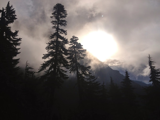
I was laying in my hammock writing this blog post when I looked out and saw this sunset view. Pretty fabulous I'd say.